- IABG Website
- Services
- Geodata & Environmental Services
- Infrastruktur & Versorgung
- IABG Website
- Services
- Geodata & Environmental Services
- Infrastruktur & Versorgung

Urbane Analysen
Tasks (Examples)
Projects
- Determination of sealed areas
- Determination of flooded areas
- Generation of raster data set 'population density' in Germany (day/night)
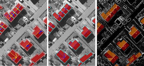
- Measurement of roof areas for solar cadastre
- Generation of 3-D city models for microcell planning
Our Services
- Construction of high-precision terrain models
- Classification according to the European Urban Atlas Classification or other international standards
- Acquisition of single buildings for cadastral applications
- Simulation of flooding scenarios for the designation of threatened areas
- 3D building and city models with derivation of population density
- Retrospective multi-temporal analysis of urban development and future growth scenarios
- Monitoring of critical infrastructure

Survey & Monitoring of Railway Infrastructure
Tasks (Examples)
Projects
- Monitoring of railway track systems after heavy rain events or landslides
- Semi-automatic recording of railway infrastructure
- Management and quality assurance of infrastructure data
- Monitoring of "greenery" in and around the track
- Ecological corridor management for overhead lines
Our Services
- Evaluation of satellite and aerial photo data
- Creation of high-resolution terrain and surface models
- Radar interferometry
- Vector data acquisition
- Automatic image analysis
- Topographic mapping
- Land use mapping
- GIS analysis
- Application development
- Database Management
How can we help you?
Please fill in the form and we will get in touch with you as soon as possible.
